

Introduction
The Islamic account of mountains explains a fundamental natural process completely backwards. The Qur’an states that mountains were placed so that the earth would not sway with people, and describes mountain ranges as stakes or pegs. Classical tafsir gives an equally direct explanation: the earth initially swayed, and mountains were then installed to make it stable. Yet the tectonic collision and deformation that build active mountain ranges such as the Himalayas also accumulate stress on the faults beneath them and produce large earthquakes. The belief that mountains are pegs that stop the earth from shaking is scientifically wrong. A part of the earth’s dynamic outer shell is presented as a restraint on that shell’s movement. In the religious account, mountains are instruments of stability; in reality, mountains themselves belong to a moving, deforming and changing earth.
Viewed from the ground, distant mountains appear immovable, massive and permanent. Their visible solidity makes it easy to imagine that they cause the earth’s stability. But an object appearing motionless and that object preventing the earth from moving are different things. The rocks beneath mountains, the faults alongside them and the motion of an entire mountain belt can be measured directly. These measurements reveal a history of crustal shortening, thickening, uplift, slip and erosion. Mountain roots also exist, but those roots are deep extensions of the moving crust itself. Mountains are not pegs driven into some fixed foundation outside or beneath the earth. The error in treating a religious metaphor as a natural mechanism lies here: a function has been inferred from a visible shape, although geological evidence does not support that function.
The chronology of mountain formation contains the same inconsistency. The hadith’s weekly creation sequence assigns the creation of soil to Saturday and mountains to Sunday. The geological record instead shows mountain building at different times, separated by tens of millions or billions of years, multiple episodes of collision, ancient mountain belts reduced by erosion, and later renewed uplift. The Himalayas are still forming; uplift and erosion also continue together in the Alps. This prolonged, non-simultaneous and continuing process does not match a story in which mountains are created on a particular day to stabilize the earth. The Qur’an’s language of mountains as pegs, the tafsir explanation that they stopped the earth’s swaying, and the hadith’s weekly timetable together constitute a mythological creation account. Presenting that account as modern geology teaches false science in defence of religious belief.
What the Qur’an Says
Verse 10 of Surah Fussilat, also known as Ha-Mim As-Sajdah, speaks of placing firm mountains on the earth’s surface. The phrase “من فوقها” means “on its upper surface”; the verse describes the location of the mountains. When this is combined with the statements of purpose in Surahs An-Nahl and Luqman, the function assigned to mountains is also clear: preventing the earth from swaying with people. The Qur’an’s claim therefore extends beyond the visible presence of mountains to how they were formed and how they relate to the earth’s movement. Alongside identifying mountains as created objects, it calls them a means of keeping the earth stable. Their location, placement and purpose of preventing swaying together form a belief in stabilization. [1]
وجعل فيها رواسي من فوقها وبارك فيها وقدر فيها أقواتها في أربعة أيام سواء للسائلين
English translation: He placed firm mountains on its upper surface, blessed it and determined its provisions in four days, equally for those who ask.
(After the creation of the earth) He placed firmly rooted mountains upon it, blessed the earth, and apportioned food in it according to the needs of those who seek it, in four days.
— Taisirul Quran (Bengali translation; rendered into English)
He set immovable mountains upon the earth and placed blessings in it, and arranged its sustenance in four days, equally for those who ask.
— Sheikh Mujibur Rahman (Bengali translation; rendered into English)
And He placed firm mountains on its upper surface and blessed it, and determined its provisions in four days, equally for those who ask.
— Rawai Al-bayan (Bengali translation; rendered into English)
And He placed firm mountains upon the earth and bestowed blessings upon it, and arranged its provisions in four days [1], equally for those who ask.
— Dr. Abu Bakr Muhammad Zakaria (Bengali translation; rendered into English)
Verse 10 of Surah Luqman directly connects the placement of mountains with “أَنْ تَمِيدَ بِكُمْ”. The Bengali translations express this as “does not move”, “does not tilt” and “does not sway”—each describes the same relationship: mountains preventing the ground from swaying. Here mountains are not being described as river sources, habitats or regulators of climate; the specific claim is that they stabilize the inhabited ground against swaying. The truth of this statement therefore depends on whether the presence of mountains actually performs that function. The fact that people can see mountains does not establish the stabilizing power attributed to them. Examining both the verse’s claim and its proposed mechanism exposes the inconsistency when earthquakes are considered. [2]
خَلَقَ السَّمَاوَاتِ بِغَيْرِ عَمَدٍ تَرَوْنَهَا وَأَلْقَى فِي الْأَرْضِ رَوَاسِيَ أَنْ تَمِيدَ بِكُمْ وَبَثَّ فِيهَا مِنْ كُلِّ دَابَّةٍ وَأَنْزَلْنَا مِنَ السَّمَاءِ مَاءً فَأَنْبَتْنَا فِيهَا مِنْ كُلِّ زَوْجٍ كَرِيمٍ
English translation: He created the heavens without pillars, as you see. He placed firmly standing mountains on the earth so that the earth would not move with you and spread all kinds of living creatures upon it. And I send water down from the sky and thereby bring forth every kind of beneficial plant.
— Taisirul Quran (Bengali translation; rendered into English)
He created the heavens without pillars, as you see. He placed mountains upon the earth so that it would not sway with you and spread every kind of living creature upon it. And I send water down from the sky and thereby bring forth every kind of beneficial plant.
— Sheikh Mujibur Rahman (Bengali translation; rendered into English)
He created the heavens without pillars that you can see, and placed firm mountains on the earth so that it would not sway with you, and spread every kind of creature upon it. And I send water down from the sky and thereby bring forth beneficial plants of every kind.
— Rawai Al-bayan (Bengali translation; rendered into English)
He created the heavens without pillars—you can see this; He placed firm mountains upon the earth so that it would not sway with you and spread every kind of living creature upon it. And We send water down from the sky and then bring forth every kind of beneficial plant upon it.
— Dr. Abu Bakr Muhammad Zakaria (Bengali translation; rendered into English)
The Function Assigned to Mountains in the Stake or Peg Metaphor
Verses 6 and 7 of Surah An-Naba describe the earth as a bed and mountains as “أَوْتَادًا”—stakes. A stake is driven in to hold something steady; the functional point of the metaphor is restraint and stability. Portraying the earth as a bed and mountains as its stakes evokes a constructed dwelling secured in place. The purpose of preventing swaying stated in other verses specifies the metaphor further, and classical commentators explained it in that sense. The fact that geology identifies deep structures beneath mountains does not establish the function assigned by the metaphor. A downward extension and the prevention of the earth’s movement by that extension are different physical phenomena; no anchoring mechanism for the latter is found. [3] [4]
أَلَمْ نَجْعَلِ الْأَرْضَ مِهَادًا
English translation: (How can you deny that I am able to create everything a second time?) Have I not made the earth a bed [for you]?
— Taisirul Quran (Bengali translation; rendered into English)
Have I not made the earth as a bed?
— Sheikh Mujibur Rahman (Bengali translation; rendered into English)
Have I not made the earth a bed?
— Rawai Al-bayan (Bengali translation; rendered into English)
Have We not made the earth a bed?
— Dr. Abu Bakr Muhammad Zakaria (Bengali translation; rendered into English)
وَالْجِبَالَ أَوْتَادًا
English translation: And the mountains—have I not made them as stakes?
— Taisirul Quran (Bengali translation; rendered into English)
And have I not made the mountains as stakes?
— Sheikh Mujibur Rahman (Bengali translation; rendered into English)
And the mountains as pegs?
— Rawai Al-bayan (Bengali translation; rendered into English)
And the mountains as pegs?
— Dr. Abu Bakr Muhammad Zakaria (Bengali translation; rendered into English)
The metaphor conveys an image of mountains being installed on the ground to stabilize it, whereas modern geology describes their origin in the opposite way. A mountain’s height and deep structure can develop together through crustal deformation and thickening. That crust belongs to a moving plate: there is no separate, already completed earth, excluding the mountains, followed by independent stakes added to secure it. Consequently, neither a mountain’s resemblance to a peg nor the existence of a root-like structure beneath it establishes the Qur’anic stabilization claim. If resemblance in shape proved function, the submerged part of an iceberg would also have to count as a device restraining the water’s movement; yet the iceberg, including its submerged portion, floats and moves. A mountain’s deep structure likewise cannot be detached from the movement of the crust as a whole.
The Same Stabilization Claim in An-Nahl and Al-Anbiya
Verse 15 of Surah An-Nahl also places mountains on the earth and the prevention of the ground’s swaying with people in the same sentence. The relationship expressed by “so that” is one of purpose and result: the mountains are supposed to keep the ground beneath people stable. Read together with the account in Luqman, this belief that mountains cause stability does not depend on an isolated word. The same relationship recurs in different surahs, and classical commentators such as Al-Tabari explain it in terms of swaying before the mountains were placed and stability afterwards. Both the location of mountains and their function therefore appear in the religious text; the conflict with geology concerns the second claim in particular. [5]
وَأَلْقَى فِي الْأَرْضِ رَوَاسِيَ أَنْ تَمِيدَ بِكُمْ وَأَنْهَارًا وَسُبُلًا لَعَلَّكُمْ تَهْتَدُونَ
English translation: He placed firm mountains on the earth so that it would not sway with you, and rivers and paths, so that you might find your way.
Verse 31 of Surah Al-Anbiya repeats the same function through “أَنْ تَمِيدَ بِهِمْ”—so that the earth would not sway with them. The creation of paths is mentioned alongside mountains, arranging the conditions for human travel and habitation within a purposeful design. The practical experience of people travelling along paths is joined to a claim that mountains stop the earth from swaying. The first relationship is verified in everyday use; the second concerns nature’s physical behaviour. Records of crustal movement, fault slip and seismic shaking do not support the second relationship. By making mountains restraints on movement in its account of a habitable world, the Qur’an introduces a specific scientific error into its description of nature. [6]
وَجَعَلْنَا فِي الْأَرْضِ رَوَاسِيَ أَنْ تَمِيدَ بِهِمْ وَجَعَلْنَا فِيهَا فِجَاجًا سُبُلًا لَعَلَّهُمْ يَهْتَدُونَ
English translation: We placed firm mountains on the earth so that it would not sway with them, and made broad paths in it so that they might find their way.
Tafsir: Explanations of the Verses
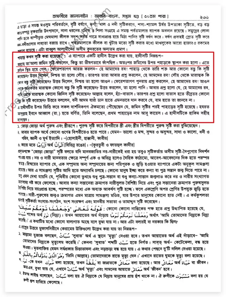
The explanatory section in the attached Bengali edition of Tafsir Al-Jalalayn describes violent shaking after the earth’s creation and the subsequent placement of mountains. It explicitly says that the ground became stable as a result of installing them. The account then compares the strength of mountains, iron, fire, water and wind before discussing charitable giving in secret. Mountains’ firmness is used to explain the earth’s stability; there is no account of crustal folding, compression or moving plates. The attached page’s claim of agreement among “all philosophers” also belongs to that explanation. Modern geology determines the chronology of mountains from the history of rocks, strata and deformation; a declaration of consensus supporting a creation story is no substitute for that evidence. [7]
When were mountains created? A hadith may be cited on this matter, as follows:
Allah created the earth, but it was shaking violently. Mountains were then placed upon it, and the earth became stable. The angels asked: “Our Lord, have You created anything stronger than mountains?” He replied: “Certainly: iron.” They asked again: “Our Lord, have You created anything more formidable than iron?” He replied: “Certainly: fire.” The angels asked once more: “Our Lord, have You created anything more formidable than fire?” He answered: “Water.” They asked again: “Our Lord, is there anything more formidable than water?” Allah said: “Yes: wind.” Then they asked: “Have You created anything stronger than wind?” He replied: “The child of Adam who gives charity with the right hand so secretly that the left hand does not know.” On the basis of this hadith, all philosophers have reached agreement that mountains were created after the earth. It is narrated from Abdullah ibn Abbas (may Allah be pleased with him) that he said the first mountain was called Abu Qubays. Al-Hakim graded this hadith sahih.
Al-Tabari: Swaying Before Mountains, Stability Afterwards
In his commentary on Surah An-Nahl, Al-Tabari describes mountains as firmly established in the ground and explains “أَنْ تَمِيدَ بِكُمْ” as preventing the earth from swaying with people. He then states in his own explanation that the earth swayed before mountains stabilized it. The presence of mountains is thus used to identify an event in the earth’s history and its cause: their installation removed instability. This relationship is the central physical claim in the Islamic belief concerning mountains. Modern geology explains mountain formation and earthquakes through the behaviour of a moving crust; Al-Tabari’s account instead imagines that dynamic crust as an object stabilized by mountains. His explanation does not match nature’s actual structure. [8]
وذلك أنه جلّ ثناؤه أرسى الأرض بالجبال لئلا يميد خلقه الذي على ظهرها، بل وقد كانت مائدة قبل أن تُرْسَى بها.
English translation: For He established the earth with mountains so that it would not sway with the creatures on its surface; it had been swaying before it was stabilized by them.
The mass and depth of mountains, and their connection to the crust, reveal no mechanism that keeps the earth motionless. A raised, thickened portion of crust belonging to a moving plate does not, by itself, stop that plate’s motion. Deformation continues beneath and beside mountains while plate collision builds them. The earth supposedly stabilized by mountains in the religious account has a solid outer shell divided into multiple moving plates. Mountains are not fixed external objects separate from that shell. Thus, in the explanation “mountains exist, therefore the ground is stable”, the proposed cause of stability has no means of performing that function in the actual structure. Both nature’s structure and the causal mechanism are misrepresented.
Al-Qurtubi: An Earth Swaying on Water
Al-Qurtubi defines “mayd” as unstable swaying from side to side. In his commentary on verse 10 of Surah Fussilat, he quotes a creation account attributed to Wahb: the earth is swaying on water, Gabriel attempts to hold it steady but is overcome by the winds, and mountains are finally used to stabilize it. In this account, mountains are stabilizing additions to an already created earth. The familiar idea of stopping movement by adding heavy objects from outside is used to explain the earth’s firmness. How the crust is composed, how it relates to the mantle, and how energy accumulates on faults do not correspond to the stabilization described in the story. [9] [10]
وقال وهب : لما خلق الله الأرض مادت على وجه الماء ، فقال لجبريل ثبتها يا جبريل . فنزل فأمسكها فغلبته الرياح ، قال : يا رب أنت أعلم ، لقد غلبت فيها . فثبتها بالجبال وأرساها وبارك فيها بما خلق فيها من المنافع .
English translation: Wahb said: When Allah created the earth, it swayed on the surface of the water. He said to Gabriel: “Gabriel, make it steady.” He descended and held it, but the winds overcame him. He said: “My Lord, You know best; I have been overcome in this.” He then stabilized and anchored it with mountains and blessed it with the useful things He created within it.
The story of stabilizing ground swaying on water with mountains effectively treats the earth as a platform whose movement can be stopped by adding weight. Actual plate behaviour depends on the structure of continental crust, oceanic crust and the upper mantle. Seawater occupies basins on the earth’s surface; continents and mountain ranges are not pegs installed from outside on a platform of water. Mountain mass can impose loads and cause crustal deformation, while deep crustal structures contribute to buoyant support. But turning that relationship into a story of the ground ceasing to sway erases the geological process. The account preserved by Al-Qurtubi records a mythological model of the world, not evidence for the earth’s actual structure.
Ibn Kathir’s Stakes: Stopping Shaking with the Inhabitants
Ibn Kathir explains the stake metaphor in Surah An-Naba directly as stabilization of the earth. In his account, mountains establish and steady the earth so that it no longer shakes with its inhabitants. “Stakes”, “stabilization” and “the end of shaking” are all joined in the same explanation. This criticism therefore does not depend on a modern speaker exaggerating the shape of mountains; the causal relationship is explicit in classical tafsir. Geology identifies thickened crust and deep faults beneath mountain ranges together. A fault producing shaking beneath inhabitants can remain active within the mountains’ deep structure. That reality conflicts with Ibn Kathir’s explanation of stabilization. [11]
( والجبال أوتادا ) أي : جعلها لها أوتادا أرساها بها وثبتها وقررها حتى سكنت ولم تضطرب بمن عليها .
English translation: “And the mountains as stakes”—that is, He made them stakes for the earth, anchoring, stabilizing and establishing it through them, until it became still and no longer shook with those upon it.
Hadith Accounts of Mountains
Report 2789 in Sahih Muslim attributes to Muhammad, through Abu Hurayra, the statement that Allah created soil on Saturday and mountains on Sunday. The same report appears as 6947 in the Hadith Academy edition and 6797 in the Islamic Foundation edition; both Bengali editions are rendered into English below. Mountain origins are placed within a weekly creation sequence, followed by assigned days for trees, other things, animals and Adam. Actual mountain formation consists of prolonged crustal changes occurring at different times in different regions. Describing that history as a Sunday act of creation does not explain nature’s chronology; it reduces geological processes to the weekly timetable of human life. [12]
خَلَقَ اللَّهُ عَزَّ وَجَلَّ التُّرْبَةَ يَوْمَ السَّبْتِ وَخَلَقَ فِيهَا الْجِبَالَ يَوْمَ الأَحَدِ وَخَلَقَ الشَّجَرَ يَوْمَ الاِثْنَيْنِ وَخَلَقَ الْمَكْرُوهَ يَوْمَ الثُّلاَثَاءِ وَخَلَقَ النُّورَ يَوْمَ الأَرْبِعَاءِ وَبَثَّ فِيهَا الدَّوَابَّ يَوْمَ الْخَمِيسِ وَخَلَقَ آدَمَ عَلَيْهِ السَّلاَمُ بَعْدَ الْعَصْرِ مِنْ يَوْمِ الْجُمُعَةِ فِي آخِرِ الْخَلْقِ وَفِي آخِرِ سَاعَةٍ مِنْ سَاعَاتِ الْجُمُعَةِ فِيمَا بَيْنَ الْعَصْرِ إِلَى اللَّيْلِ
English translation: Sahih Muslim (Hadith Academy)
Chapter: 52. Accounts of the Day of Judgment, Paradise and Hell
Publisher: Hadith Academy
Section: 1. The beginning of creation and the creation of Adam (peace be upon him)
6947-(27/2789) Surayj ibn Yunus and Harun ibn Abdullah (may Allah have mercy on them) … from Abu Hurayra (may Allah be pleased with him). He related: Allah’s Messenger (peace and blessings be upon him) took my hand and said: “Allah created the soil on Saturday and created the mountains in it on Sunday. On Monday He created trees. On Tuesday He created adversities. He created light on Wednesday. On Thursday He spread animals and birds over the earth, and on Friday, after Asr, He created Adam (peace be upon him) as the last creation, at the final moment of Friday, between Asr and night.” (Islamic Foundation 6797; Islamic Centre 6851)
Hadith grading: Sahih
Sahih Muslim (Islamic Foundation)
Chapter: 53. Accounts of the Day of Judgment, Paradise and Hell
Publisher: Islamic Foundation
Section: 2. The beginning of creation and the creation of Adam (peace be upon him)
6797. Surayj ibn Yunus and Harun ibn Abdullah (may Allah have mercy on them) … from Abu Hurayra (may Allah be pleased with him). He related: Allah’s Messenger (peace and blessings be upon him) took my hand and said: “Allah created the soil on Saturday. On Sunday He created mountains in it. On Monday He created trees. On Tuesday He created adversities. On Wednesday He created light. On Thursday He spread animals and birds over the earth, and on Friday, after Asr, He created Adam (peace be upon him): at the final hour of Friday, between Asr and night, as the last of creation.”
Hadith grading: Sahih
The conflict between this timetable and geology is not confined to whether mountains can form after soil has formed. Mountains developed after the earth’s crust formed, and new mountain building continues today. The conflict consists in replacing nature’s prolonged, multi-stage history with a creation story unfolding over a few consecutive days. Himalayan collision, ancient deformation in the Aravalli belt and later renewed uplift in the Urals are different events, separated by enormous spans of time. Their separate histories remain recorded in the rocks. A belief about the weekday on which mountains were created cannot explain their formation ages, rock metamorphism or continuing rates of uplift. The religious timetable is inconsistent with geological history.
Hadith scholars have also challenged the attribution of this report in Muslim to Muhammad. Islamweb’s compiled discussion cites Al-Bukhari’s view that treating it as a statement of Ka‘b Al-Ahbar is more accurate. Its inclusion in Muslim and Al-Bukhari’s objection concerning its source belong to the history of preserving and evaluating religious reports. The written basis for the belief that mountains stabilize the ground is not confined to this report: it also appears in several Qur’anic verses and the commentaries of Al-Tabari, Al-Qurtubi and Ibn Kathir. The collection’s religious standing supplies no geological evidence for this creation timetable. Substituting the status of a book for evidence from rock strata and distinct episodes of mountain building makes religious authority a guarantee of the truth of natural history. [13]
Al-Tirmidhi and Mishkat: The Earth Becomes Stable When Mountains Are Placed
Al-Tirmidhi 3369 explicitly gives the sequence in which the ground first swayed and became stable after mountains were placed on it. The Bengali explanation of Al-Jalalayn quoted in the original article and the printed Mishkat pages present the same account. The attached critical note records Al-Albani’s grading of da‘if; Al-Tirmidhi calls the report “gharib” and says that he knows no other route by which it is transmitted as a report attributed to Muhammad. Repetition of the same account in several books does not constitute several independent observations. Its significance is the written record of how religious interpretation used mountains to explain the earth’s stability. The reported result is unambiguous: after the mountains are installed, the earth becomes stable. [14] [15]
لَمَّا خَلَقَ اللَّهُ الأَرْضَ جَعَلَتْ تَمِيدُ فَخَلَقَ الْجِبَالَ فَعَادَ بِهَا عَلَيْهَا فَاسْتَقَرَّتْ فَعَجِبَتِ الْمَلاَئِكَةُ مِنْ شِدَّةِ الْجِبَالِ
English translation: When Allah created the earth, it began to sway. He then created mountains and placed them upon it; it then became stable. The angels were astonished at the mountains’ firmness.

The attached Mishkat explanation expands the story further: first the ground of the Kaaba, then its extension, a dish- or board-like state on water, subsequent movement, and stabilization by installing mountains. Imagining the earth’s structure through the behaviour of familiar dishes or boards does not match geological reality. The earth’s solid outer shell is not a continuous, immovable board; its plates move relative to one another. Mountain building is part of that shell’s deformation. Treating the earth as a shaky platform and mountains as additional objects that stabilize it therefore starts with an incorrect physical structure. The explanation of stability built on that incorrect structure does not match the actual relationship between mountains and earthquakes. [16]
Explanation: When Allah first created the ground of the Kaaba, heated it and spread it out all around, it became like a dish or board on water. That ground then began to move and sway violently. The angels even said that humankind would be unable to benefit from this earth. Allah then created mountains and placed them in the ground so that it would remain stable in its own place and not move from it. In this connection Allah says in the Qur’an: وَأَلْقَى فِي الْأَرْضِ رَوَاسِيَ أَنْ تَمِيدَ بِكُمْ, meaning: “And He placed firm mountains on the earth so that the earth would not sway with you.” (Surah An-Nahl 16:15)

Statements by Islamic Scholars
Religious promotion of mountains as the earth’s pegs is not confined to the pages of old tafsir. A video below records Bangladeshi preacher Mizanur Rahman Azhari’s remarks about mountains as pegs. This presentation applies a familiar object’s function—fastening something with a peg—to the entire earth. But with a wooden board, it is possible to see where the peg enters and how it joins two objects; there is no geological evidence for mountains being driven into a separate, fixed foundation beneath the earth. Treating visible height and mass as assurances of stability gives the audience a simple picture, while leaving the crust’s actual movement and deformation outside that picture.
The original article also included two further videos of religious remarks concerning the causes of earthquakes; they are retained below. The claim that mountains stabilize the earth creates a fundamental problem for any accompanying explanation of earthquakes: why does the ground shake with the mountains supposedly installed to stabilize it, and where exactly does that shaking originate? Geology identifies sources by measuring seismic waves, fault slip and crustal deformation. A speaker’s standing or religious authority is no substitute for those measurements. Changing an event’s actual causal explanation to fit a religious account spreads misconceptions about earthquakes. Replacing evidence of fault slip and rock deformation with a preacher’s beliefs obscures their actual causes.
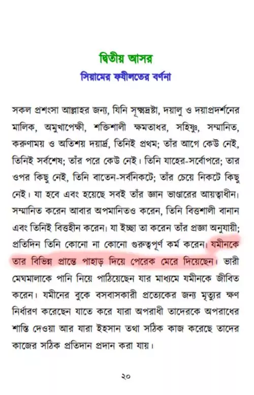
The Bengali translation of Muhammad ibn Salih ibn Uthaymin’s Thirty Sessions in Ramadan uses the same language of pegs. At the beginning of the second session, its description of Allah’s creative power states that mountains were driven in as pegs at different extremities of the earth. The metaphor is presented as an act in constructing the earth. Making mountains instruments of that act conflicts directly with modern geology: mountain ranges belong to the moving lithosphere, rather than being fixed stakes restraining it from outside. However emphatically a religious text praises this belief, that praise does not change the mountains’ crustal structure. The peg explanation carries the stabilization imagined in classical tafsir into modern religious teaching. [17] [18]
He has driven mountains in as pegs at the earth’s different extremities.
The Geological Reality of Mountains and the Qur’anic Conception
According to modern geology’s theory of plate tectonics, the earth’s solid outer shell is divided into several large and small plates. The crust and the rigid uppermost mantle together form this lithosphere. Plates converge, separate and slide past one another, deforming rocks at their boundaries and within them. Compression, folding of rock layers, the thrusting of one block over another along faults, and crustal thickening are important in mountain building. Mountain ranges are not independent pegs subsequently installed on an already completed earth; they result from changes in the earth’s outer shell. The mountain made into a restraint on the ground’s movement in the Qur’anic stabilization account contains, in its very formation, a history of crustal movement and deformation. [19] [20] [21]
Collision between the Indian and Eurasian plates has shortened and thickened the crust in the Himalayas, producing a mountain range. The same collision continues today. Mountain elevation changes involve erosion and fault movement as well as uplift, so a single, unchanging annual rate of height increase cannot be assigned to the entire Himalayas. In the actual structure, the mountains’ upper portions, the deep crust and the principal fault beneath them form an interconnected system. Mountains cannot be placed outside that system and assigned the task of stopping its movement. Deformation continues as the crustal process building the Himalayas continues; there is no stage at which forming the mountains makes the earth stable. Geology provides no counterpart to the religious account’s one-time transition from instability to stability. [22]
Measured Shortening in the Himalayas and Zagros: Movement Has Not Stopped
Hatzfeld and Molnar’s 2010 comparative study gives horizontal shortening rates of approximately 18–20 millimetres per year in the Himalayas and 6–10 millimetres per year in the Zagros. The same study compares an India–Eurasia collision age of approximately 45–55 million years with an Arabia–Eurasia collision age of approximately 23–35 million years. The two mountain belts differ in collision age, total shortening and crustal thickness. These differences are explained through different stages of mountain building and continuing deformation. The idea that the earth became stable after mountains were installed cannot account for these distinct rates and histories. Measurements show movement of mountain belts alongside the mountains’ continuing existence. [23]
Subsequently, slip on thrust faults stacked slices of India’s basement to build the Himalaya on India’s northern margin.
Horizontal shortening and the vertical increase in a summit’s elevation are different quantities. A mountain belt can narrow, its internal rocks can fold, blocks can move over one another along faults, and exposed rocks can erode. Mountain height and deep crustal structure change together through these relationships. The story of installing ready-made stakes to hold the earth steady has no place for this continuing transformation. Measured shortening in the Himalayas and Zagros shows that the crust belonging to them continues to deform under the continuing collision after mountains have formed. Mountains have not stopped that deformation; their structure records it. The religious explanation of stabilization directly contradicts this visible and measurable history.
Mountain Building and Earthquakes: Long and Short Timescales of the Same Deformation
The long history of an active mountain belt and an earthquake lasting a few seconds within it are not disconnected events. Plate movement deforms rocks; if part of a fault remains locked, strain can accumulate. When the fault suddenly slips, energy stored in elastic strain is released as seismic waves. Many earthquake cycles, together with permanent deformation, contribute to the mountain belt’s long-term development. The 2021 review of the Himalayas analyses this relationship between prolonged tectonic change and the seismic cycle. Instead of supporting the claim that mountains stop the earth from shaking, the evidence identifies earthquake-generating faults within the mountains’ deep structure. Separating the mountains’ origin from the source of earthquakes and inserting the peg story falsely treats two behaviours of the same system as opposites. [24]
At shorter (decadal) timescales, tectonic geodesy reveals that elastic strain is periodically released via earthquakes.
The weight of mountains does not prevent relative slip between rocks on either side of a fault. Crustal structure, stress distribution, rock properties and fault geometry determine where strain can accumulate and how it may be released. Imagining a mountain as a simple heavy object that suppresses ground shaking does not explain these processes. A massive mountain is not, by its presence alone, an earthquake-prevention mechanism; mountains do not have to be removed for a large earthquake to occur beneath an active range. The error in the religious stabilization explanation therefore goes beyond the coexistence of mountains and earthquakes. Following the actual causes shows that crustal movement produces both mountain building and fault slip; neither necessity nor evidence supports making mountains an external controller of the system.
Deep Mountain Roots Do Not Anchor the Earth Like Pegs
Deep crustal structures beneath mountains are explained through isostasy. In the Airy model, crust is thicker beneath high terrain; a deeper extension of relatively low-density crust compensates for the additional mass above. The Pratt model explains differences in elevation through differences in density. This balance can be compared with a floating iceberg: a submerged portion extends beneath the visible part. The deep structure belongs to the crust itself; it is not a stake binding the earth to some other immovable object. A peg fastens two objects together, whereas isostasy explains relationships between mass, density and buoyant support. These are different physical relationships. [25] [26]
Equilibrium in a floating object does not stop its lateral movement; likewise, vertical crustal balance does not mean an absence of relative plate motion. A mountain’s deep structure moves with its plate and can deform and change. If neighbouring faults are active, people above can experience earthquakes. It is therefore logically inconsistent to infer “mountains prevent the earth from swaying” from the fact that “mountains have roots”. The premise provides no evidence for the movement-restraining function inserted into the conclusion. Declaring the religious peg belief scientific by showing an image of a mountain’s hidden deep structure substitutes similarity of shape for identity of function. The actual model describes equilibrium; it contains no arrangement of pegs holding the earth motionless.
In the Himalayas, the problem is more direct because the Main Himalayan Thrust lies within the mountain range’s roots. An important part of the earthquake cycle occurs in the very deep structure presented as a guarantee that the ground will not shake. Considering thickened mountain crust together with the fault beneath it dismantles the peg explanation: that deep structure belongs to the continuing collision system rather than immobilizing the ground. Mentioning “roots underneath” while excluding the accompanying evidence of active faults and deformation does not explain mountain geology. It uses scientific vocabulary to draw a conclusion stronger than the evidence supports in favour of the Qur’anic stabilization claim. That conclusion is wrong. [27]
Nepal and the Alps: Direct Evidence of Crustal Movement and Shaking with Mountains Present
The Gorkha earthquake in Nepal on 25 April 2015 had a magnitude of 7.8. Seismic and displacement studies identify slip across an area of approximately 150 × 60 kilometres on the Main Himalayan Thrust. The specific source of the shaking was therefore a major fault beneath the mountain belt, where relative movement between the Indian and Eurasian plates had accumulated strain. The Himalayas and their deep crustal structure were present during the event. The movement-restraining function attributed by the religious explanation to mountains as stabilizing stakes is absent from this structure. Instead, maps and models can describe how accumulated strain within the crust, including the mountains, was released. The conflict with the religious claim concerns the actual behaviour of a measured fault, rather than an indistinct objection. [28]
According to the USGS account, that earthquake shifted Everest approximately 3 centimetres southwest; its summit neither rose nor fell during the event. This displacement exposes the error of treating a mountain as a fixed stake: the mountain itself moves with crustal displacement. Measuring long-term uplift separately from an earthquake’s instantaneous slip makes their respective roles clear. Describing mountain formation as a process unfolding over hundreds of thousands of years and the earthquake as a brief slip on a fault beneath it produces an explanation consistent with observation. The story of mountains stabilizing the earth lacks that relationship. It assumes stability, while measurements directly register movement of the ground and its mountains. Everest’s displacement shows the actual opposite of the claim that mountains hold the earth in place like pegs. [29]
Deep mountain crust and earthquakes also coexist in the Alps. The Swiss Seismological Service reports that the Moho—the crust–mantle boundary—can lie more than 50 kilometres beneath the Alps, while earthquakes occur in the upper crust down to about 20 kilometres. Despite the deep roots, hard rocks above them fracture and move. The same institution connects the region’s mountain building and seismicity with collision between the European and African/Adriatic plates. The claim that mountain depth guarantees stability therefore fails against observation. Mountains supported by deep roots still belong to a dynamic system containing faults; their weight does not make the earth free of shaking. The measured depths and the presence of earthquakes directly disprove the peg explanation. [30]
Erosion, Uplift and Volcanism: Mountains Are Constantly Changing
A mountain’s geological history does not stop at its height. Rain, rivers, glaciers and weathering break down rock, and eroded material is deposited elsewhere. Loss of overlying mass can produce isostatic uplift, while sediment loads elsewhere can make the underlying crust subside. Mountain erosion and the movement of the crust beneath it are therefore interconnected parts of the same system. Mountains erode while the crust adjusts its balance—an observation incompatible with the idea of a fixed peg. Assigning mountains the permanent function of restraining the earth does not explain these changes. Mountains rise, are reduced by erosion and can be uplifted again; these are outcomes of continuing relationships between the earth’s structure and the forces acting upon it. [31] [32]
In an Andean-type mountain belt, an oceanic plate descends beneath another plate. Water released from hydrous minerals in the descending plate can lower the melting temperature of the overlying mantle and promote partial melting; the resulting magma rises and forms volcanoes. Compression, faulting and crustal thickening in the same region also contribute to mountain building. The first panel of the original diagram below shows subduction and the second continental collision. These are distinct types of mountain-building processes. Neither resembles a finished mountain being installed from outside to stabilize the earth after soil has been created. Whether volcanic material is added or existing crust is folded and uplifted, mountains originate within the earth’s continuing physical changes. [33]
Mountain Formation: Two Distinct Tectonic Processes
A) Subduction (for example, the Andes)
B) Continental Collision (for example, the Himalayas)

Formation Periods, Ages and Characteristics of the World’s Major Mountain Ranges
Determining the chronology of a mountain range involves distinguishing rock age, the timing of deformation and the uplift of the present high landscape. Some metamorphic rocks in Rocky Mountain National Park are approximately 1.8 billion years old, while the area’s principal Rocky Mountain uplift began about 70 million years ago. Old rocks can later be raised to form a new landscape. These separate events leave records in rocks and landforms, making it possible to reconstruct mountain history independently of a declaration about a particular creation day. The table below retains eight mountain ranges, their episodes of formation, associated plate relationships and selected characteristics. Their histories do not share a single timetable; even within one mountain belt, changes can begin at different times and proceed differently in different parts. [34]
| Mountain range | Location | Formation period | Approximate age | Formation mechanism | Notable characteristics |
|---|---|---|---|---|---|
| Himalayas | South Asia (India, Nepal and Tibet) | Cenozoic; India–Eurasia collision and Himalayan mountain building beginning about 50 million years ago | A formation history of approximately 50 million years; present uplift rates vary by location | Continental collision between the Indian and Eurasian plates | Everest is the world’s highest summit (~8,849 metres); collision continues. [35] |
| Alps | Europe (France, Switzerland, Austria and elsewhere) | Cretaceous subduction followed by the principal Cenozoic continental collision from approximately 35 million years ago | Principal continental collision approximately 35 million years ago; subsequent uplift and erosion continue | Collision between the African/Adriatic and Eurasian plates | Numerous glaciers; source region for many major European rivers. [36] |
| Andes | South America (Chile, Peru, Bolivia and elsewhere) | Subduction since the Jurassic; principal Andean mountain building since the middle–Late Cretaceous; active in the Cenozoic | ~100 million years (varying by region) | Subduction of the Nazca plate beneath the South American plate | The world’s longest continental mountain range (~7,000–8,000 km); numerous active volcanoes. [37] |
| Rocky Mountains | North America (United States and Canada) | Laramide orogeny (~80–55 million years ago) | ~55–80 million years | Inland compression and uplift associated with low-angle subduction | Extensive uplands and national parks; the prominent Front Range. [38] |
| Urals | Russia (the Europe–Asia boundary) | Late Paleozoic (Carboniferous–Permian, ~350–250 million years ago) | ~250–350 million years | Collision of ancient Baltica, Kazakhstania and associated terranes; prolonged Uralian orogeny | Recognized as a geographical Europe–Asia boundary; the present landscape also records later renewed uplift. [39] |
| Aravalli | India (associated belt extending through Rajasthan, Gujarat, Haryana and the Delhi region) | Multiple Proterozoic orogenies; a principal Aravalli phase approximately 1.8–1.7 billion years ago, with later Delhi-belt phases around 1 billion years ago | Ancient basement rocks, the principal Aravalli orogeny and the later Delhi orogeny have different ages | Ancient continental collision and multiple orogenic cycles | An ancient fold belt; prolonged erosion has left low mountains and residual landforms. [40] |
| Zagros | Iran and Iraq | Different Oligocene–Miocene phases of collision and shortening; development continues | Estimates for collision onset range from approximately 35 to 23 million years ago; subsequent folding and uplift represent separate phases | Fold-and-thrust belt produced by collision between the Arabian and Eurasian plates | Major oil and gas resources; pronounced folding. [41] |
| Atlas | Morocco, Algeria and Tunisia | Additional surface uplift following Cenozoic folding and crustal thickening | Formation of the fold belt and attainment of its present elevation differ in age; evidence records post-Miocene and post-Pliocene uplift | Africa–Europe convergence and shortening within the continental interior | A long Maghreb mountain belt, with high plateaus and valley systems. [42] |
An enormous interval separates the Himalayas’ prolonged collision history from Proterozoic deformation in the Aravalli belt. The Urals also record a distinct neo-orogenic phase after ancient mountain building; in the Atlas, formation of the folded belt and later uplift responsible for its present elevation are not the same event. These separate histories reveal a constantly changing earth. Nature contains no identifiable episode in which mountain creation was completed simultaneously everywhere. Assigning “mountains” to Sunday in a timetable does not explain this history; it replaces questions about the actual crustal events forming particular mountains with a mythological declaration. Calling that declaration science while disregarding distinct formation ages and continuing uplift is misleading. [39] [43]
Geological dating gains its strength from matching different kinds of evidence within a common history: relationships between strata, metamorphism, folds and faults, ancient erosion surfaces and subsequent sedimentary records. Identifying a mountain solely with the age of its rocks is mistaken; explaining its origin through a weekly creation story likewise erases the actual events. Analysis of the sequence of mountain building and erosion establishes the causes and timing of change. The religious account substitutes a declaration of the Creator’s action for that evidence. Giving an evidentially established long history and a timetable proclaimed in a sacred account the same status as knowledge preserves the creation story’s misinformation while obscuring the mountain’s actual history.
The Causal Error in the Belief That Mountains Are Pegs
Three relationships expose the error in the claim that mountains prevent the earth from swaying. The crust to which mountains belong is itself moving; deep mountain roots provide buoyant support rather than stakes anchored to an external fixed foundation; and strain accumulation and release on faults in active mountain belts produce earthquakes. Taken together, these established relationships leave no physical role for mountains as restraints on the earth’s movement. Claiming that the motion responsible for building mountains ceased because the mountains exist reverses the causal explanation. Mountain mass and depth are real, but the peg function assigned to those real characteristics is unsupported. Geology does not substantiate the function assigned to mountains in the Qur’an and tafsir.
Multiple earthquakes, together with the crust’s deep structure and long history, disprove the belief in stabilization by mountains. Deep faults in mountain belts, crustal displacement, prolonged shortening, and the relationship between erosion and uplift all document the same dynamic earth. Fault slip beneath Nepal’s mountains and seismicity above the Alps’ deep roots are measured examples of that structure. Mountain shape or visible mass cannot establish the stabilization story. A metaphor used to support a belief is not a scientific explanation when its purported physical function does not occur in nature. For mountains, there is positive evidence of movement and deformation as well as an absence of support for the claim. The religious stabilization claim is wrong because it contradicts that evidence.
The distribution of earthquakes also follows plate boundaries and faults. The USGS identifies the circum-Pacific belt, the belt extending through the Himalayas to the Mediterranean, and the Mid-Atlantic Ridge among the principal seismic regions. Explaining this distribution does not require treating mountains as pegs that stabilize the earth after creation. Natural processes are understood through the locations of subducting plates, colliding continents, separating plates and faults capable of slipping. Using mountains’ existence as proof of their supposed function does not test the claim: mountains were created to stabilize the earth, and the earth is stable because mountains exist. The same belief is thus made its own evidence. Actual evidence shows that the earth’s outer shell, including its mountains, is moving. [44]
Shongshoy’s “What Was the First Creation in Islam: Water, the Pen, the Throne, or Light and Darkness?” discusses further Islamic source accounts of the beginning of creation. The mountain narrative belongs to that broader creation belief: familiar objects, familiar timetables and supernatural acts are used to explain nature’s origins. For mountains, the result is a stabilization story that denies the earth’s actual dynamism. The mass and solidity visible to ancient observers were assigned the function of stakes installed by the Creator. Continuing to promote that story as science after modern geology has established mountain structure and motion goes beyond a straightforward inheritance of ignorance: it presents a belief contradicted by evidence as scientific knowledge.
Conclusion
The Islamic mythology of mountain origins and chronology amounts to a childish creation tale. These ridiculous Islamic fables are wholly incompatible with modern scientific knowledge. Such childish stories may be told to small children, but accepting them as truth creates a problem: it distances people from science education and encourages an increasingly narrow-minded and superstitious outlook. Recognizing these accounts as tales from the past and acquiring a modern education are therefore essential for all of us.
The problem with the Qur’anic account of mountains is specific and testable: its claim that installing mountains stopped the earth’s swaying does not match actual geological structure. Al-Tabari describes swaying before mountains and stability afterwards; Al-Qurtubi relates a story in which mountains steady ground swaying on water; and Ibn Kathir explains the function of stakes as stopping the shaking experienced by inhabitants. Geology instead identifies moving plates, deformed crust, deep faults and the release of stored energy. Mountains are an outcome and a component of this system; assigning them the role of restraining its movement is wrong. The function claimed in the religious account contradicts nature’s observed behaviour. Inclusion in a sacred book does not make that inconsistency true.
Neither mountain height, deep roots nor enormous mass proves that mountains peg the earth in place. The very depths invoked to substantiate the religious claim contain active faults and a record of earthquakes. A mountain presented as a symbol of stability itself moves during an earthquake. Mountains described as objects created on a particular day record formation and change through events spanning tens of millions and billions of years. Calling the Qur’anic stabilization account geological truth while disregarding this evidence is a false scientific claim. Mountains are not the earth’s pegs; they belong to its moving and changing outer shell. This Islamic stabilization belief is an ancient creation myth, not empirically established knowledge.
References
- Qur’an 41:10 ↩︎
- Qur’an 31:10 ↩︎
- Qur’an 78:6 ↩︎
- Qur’an 78:7 ↩︎
- Qur’an 16:15 ↩︎
- Qur’an 21:31 ↩︎
- Tafsir Al-Jalalayn, Arabic–Bengali edition, vol. 7, p. 261 ↩︎
- Tafsir Al-Tabari, An-Nahl 16:15 ↩︎
- Tafsir Al-Qurtubi, Fussilat 41:10 ↩︎
- Tafsir Al-Qurtubi, An-Nahl 16:15 ↩︎
- Tafsir Ibn Kathir, An-Naba 78:7 ↩︎
- Sahih Muslim 2789; Hadith Academy 6947; Islamic Foundation 6797 ↩︎
- Islamweb, fatwa 137773: evaluation of the report about soil being created on Saturday ↩︎
- Jami Al-Tirmidhi 3369 ↩︎
- Tirmidhi Sharif, vol. 6, Islamic Foundation, p. 83 ↩︎
- Critical edition of Mishkat Al-Masabih, Hadith Academy, vol. 3, pp. 716–717 ↩︎
- Thirty Sessions in Ramadan, second session, p. 20 ↩︎
- Attached printed page from the Bengali translation of Ibn Uthaymin’s work ↩︎
- Tarbuck, E. J., & Lutgens, F. K. (2014). Earth: An Introduction to Physical Geology ↩︎
- Kearey, P., Klepeis, K. A., & Vine, F. J. (2009). Global Tectonics ↩︎
- USGS, The Himalayas: Two continents collide ↩︎
- Dal Zilio et al. (2021), Building the Himalaya from tectonic to earthquake scales 1 2
- Hatzfeld & Molnar (2010), Reviews of Geophysics 48, RG2005; Table 1 ↩︎
- Dal Zilio, Hetényi, Hubbard & Bollinger (2021), Nature Reviews Earth & Environment 2, 251–268 ↩︎
- Watts, A. B. (2001). Isostasy and Flexure of the Lithosphere ↩︎
- Hong Kong Observatory, What is isostasy? ↩︎
- Dal Zilio et al. (2021): deep Himalayan structure and the Main Himalayan Thrust ↩︎
- McNamara et al. (2017), Source modeling of the 2015 Mw 7.8 Nepal (Gorkha) earthquake sequence, Tectonophysics 714–715, 21–30 ↩︎
- USGS, M7.8 Nepal Earthquake, 2015 – A Small Push to Mt. Everest ↩︎
- Swiss Seismological Service: crustal depth and Alpine seismicity ↩︎
- Summerfield, M. A. (1991). Global Geomorphology ↩︎
- Hong Kong Observatory: sedimentation, erosion and isostatic effects ↩︎
- CUNY, Making Magma: How to Melt Rocks 1 2
- National Park Service, Geologic Activity: ancient rocks and subsequent mountain uplift ↩︎
- USGS, The Himalayas ↩︎
- Swiss Seismological Service, Alps ↩︎
- Schellart (2017), Nature Communications 8, 2010 ↩︎
- NPS, Rocky Mountain National Park: local uplift beginning about 70 million years ago ↩︎
- Puchkov (2013), Structural stages and evolution of the Urals 1 2
- Singh et al. (2021), Frontiers in Earth Science: Aravalli–Delhi orogenic cycles ↩︎
- Hatzfeld & Molnar (2010), Reviews of Geophysics ↩︎
- Babault et al. (2008), Terra Nova 20, 102–107 ↩︎
- Babault et al. (2008), A Late Cenozoic age for long-wavelength surface uplift of the Atlas Mountains of Morocco ↩︎
- USGS, Where do earthquakes occur? ↩︎
